How Do Clouds Affect Morning Temperatures?

Well, no matter where you live, if you are an avid weather watcher, you may have noticed that for any season of the year morning low temperatures seem to be related to cloud cover.  When its cloudy morning low temperatures don’t seem to be as cold.  You are correct!  Now there are exceptions to every weather day, sometimes it can be a cloudy morning and a huge cold front with Canadian air is blasting through your city and morning lows are very cold.  However in the absence of cold air moving in from somewhere else that is colder, morning lows will be colder when it is clear than when it is cloudy.

Clouds act as a blanket.  Because they are made of water vapor they are very effective absorbers of energy trying to escape from the Earth’s surface to space at night.  This energy that is lost to space at night from the Earth’s surface is called “outgoing longwave radiation”.  On clear nights this “longwave energy” is free to move through the atmosphere and to space, thus allowing the surface temperature to cool significantly.  On cloudy nights the longwave energy is absorbed by clouds and some energy is radiated back to the surface so temperatures are slower to fall and morning low temperatures will typically be warmer when it is cloudy than when it is clear.

The same process is in place on very humid compared to very dry nights.  Water vapor in the air even if it has not formed clouds can absorb and radiate some longwave energy back to Earth, thus humid nights will typically not get as cold as dry nights…assuming you start with the same temperature at dusk.

This simple cloud/water vapor blanketing effect occurs everywhere, but because clouds and water vapor vary from place to place typical nighttime cooling amounts vary.  For example in deserts where we have very dry air and few clouds the day to night temperature difference is very large sometimes 40-50 degrees F.  Near cloudy humid coastlines like Los Angeles and San Diego, Houston or Miami day to night temperature differences are much lower typically 20 degrees F thanks to the cloud blanketing effect….of course a nearby ocean temperature that changes temperature little from night to day also contributes in these locals.

So if the weatherman forecasts a very cold clear early morning, but clouds move into your area overnight that were not expected, nearly always the measured morning low temperature will be warmer than what the weatherman forecast!

Interestingly clouds have the opposite affect during daytime, primarily because they physically block some sunlight from reaching the Earths surface making it unavailable to warm the ground.  This shadow affect is aided by the fact the cloud tops reflect sunlight back to space! Hence we all obviously know that cloudy day high temperatures will typically  be lower than sunny day  high temperatures in the same weather patterns and times of the year.

Isn’t the atmosphere a marvelously simple yet complex thing!      : = )


Why Isn’t Daytime Maximum Temperature At Noon?

Why you might ask does the daily maximum temperature not occur at noon when the sun is highest and hottest and the most energy is reaching the Earth?  Well, to simplify let us assuming first that there are no cold fronts, clouds, or big weather changes that might cause temperatures to change…its a nice clear fair weather day.  The answer is simple, Earth’s surface temperature is controlled by the NET energy input from the sun, not the daily maximum value.  So on a typical day when the sun comes up, sunshine adds energy to the surface and warms it.  The rate of warming is based on the energy surplus so the maximum warming RATE will typically occur near noon.  But the suns energy SURPLUS to earth will continue to warm the Earth’s surface until there is no energy  surplus.  If there is an energy deficit then Earth will cool.  So on a typical day the Earth’s energy surplus continues long after the peak surplus (near noon) so the Earth continues to warm well after high-noon until there is no longer an energy surplus.   This is typically late afternoon in most areas…hence the daytime high temperature is usually observed between about 2 pm and 6 pm at the time the energy surplus drops back to zero, once it turns negative then the Earth surface begins to cool…until a surplus is once again occurring!

The Latest Date In The Year A Major Hurricane Has Struck The U.S. …Did You Know

Did you know that October 25th is the latest calendar date (on record back to 1851) that a major hurricane(CAT 3/4/5) has made landfall in the U.S.?  What a hurricane that was too.  It made landfall as a CAT 3 on the Saffir-Simpson hurricane wind scale!  Peak winds were estimated to be near 140 mph with a lowest pressure of 941 millibars at the time.

But here is the rest of the story…..

The hurricane had no name, naming began much later than 1921 (naming started in 1950, women’s names starting in 1953), so this “great hurricane” is just called the “1921 Tampa Bay Hurricane.”  What is even more interesting is that same city of Tampa Bay has not been struck by another major hurricane since!  No, for 93 years it will have dodge a major hurricane strike if it is successful for the rest of this year.  Hurricanes have struck or given glancing blows to Tampa Bay over the years but no CAT 3 or higher has struck the city for a very long time.

There is no magic barrier however, this is partly just random good luck, and partly it is that hurricanes must be moving from the southwest or west or northwest to strike Tampa directly…rare directions for major hurricanes and directions most common in June and November!  Those hurricanes coming in from the east will nearly always weaken well below major hurricane strength before they cross Florida and strike Tampa.  The next major hurricane in Tamp Bay will have a name, assuming we have not changed our hurricane identification convention by then! 🙂

Sundogs Chasing the Sun at 22 Degrees

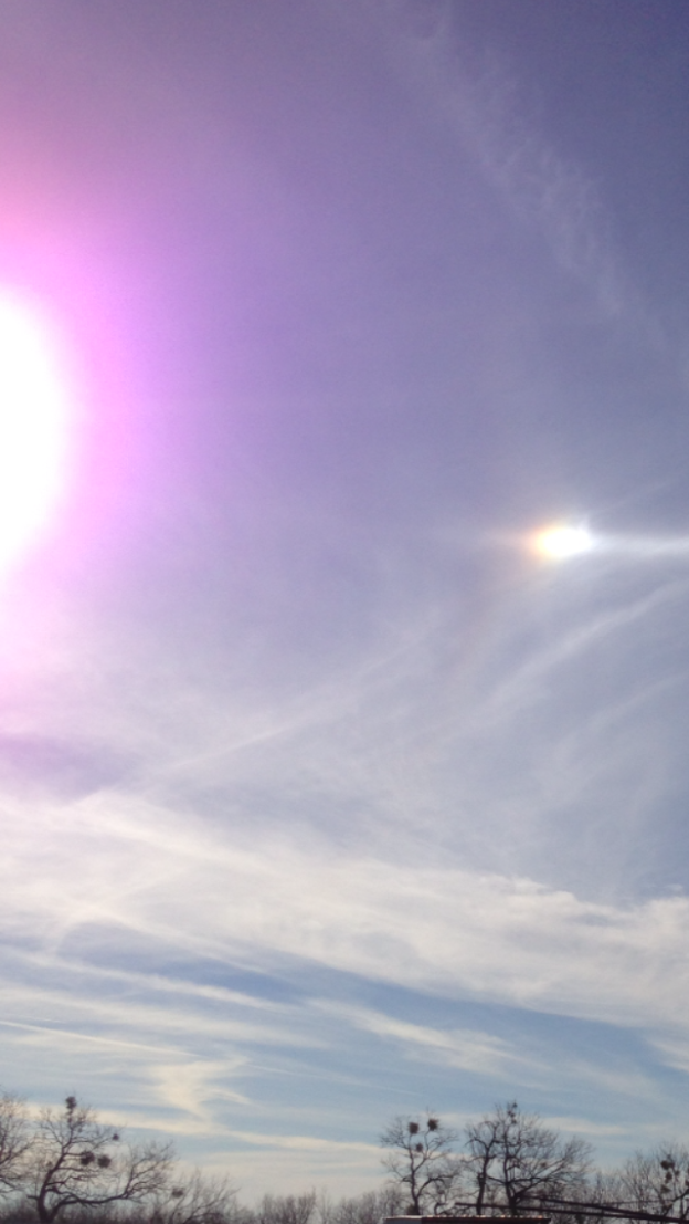
Sundogs are small rainbow like bright spots that are typically found about 22 degrees on either side of the sun.  Almost exclusively they are only seen through a thin layer of high clouds.  Their cause is the refraction of light from the sun through ice crystals that make up clouds at mid and high levels in the atmosphere.  The ice crystal geometry makes the refraction such that the light will appear 22 degrees from the sun (180 is from horizon to horizon) and in rare situations 44 degrees from the sun when ice crystals orient themselves in a unique way.  The sundog name has many apparent origins, but I believe myself that people saw the dog tagging along with his owner (the sun).  You can see the sundog in this image 22 degrees to  the right of the sun…there may be another on the left side of the sun at times mirror image sundogs depending upon the symmetry of the high clouds around the sun. Be careful to not look direction at the sun when looking at sundogs, even if you have sunglasses on!

Rainbows & Double Rainbows

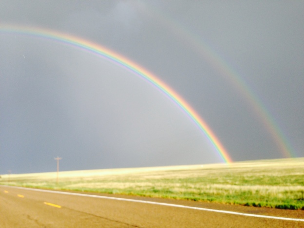
Check out my facebook post of a double rainbow photo. These are often called first and second order rainbows. A third order rainbow can only be seen by looking into the sun…rare and I don’t advise that! The first order or primary rainbow is most common, and has the red colors on the top and the blues/violets on the bottom of the rainbow. The color split is caused by a prism-like separation of refracted sunlight into its colors ordered by the wavelength of each color, the reds are longest and hence bent most, the blues/violets shortest and hence are bent less. The refraction caused by light moving through air and then water. Note that very often inside the “primary” rainbow the sky is brighter or more well lit than outside the rainbow. This is because rain drops are not perfect spheres and some light is preferentially reflected toward the inside portion of the rainbow.

When a second order rainbow is visible it is nearly always fainter and the color order is reversed, red is on the bottom side! This is because this second bow is cause by one additional reflection of light within the raindrops, that reflection dims the bow but like a single mirror reflection reverses the image (hence the colors). Details on exactly how reflection and refraction of light through raindrops occurs gets complicated but these details are not necessary to provide you this fundamental understanding. Of course to see a rainbow turn your back to the sun and look toward the rain. The extent of the rainbow will depend on the arial extend of rain and the sun angle. Near sunset and looking into a large rain area, nearly half-circle of rainbow may be seen.

Weather Trivia Questions Answered…

1) Is cloud to ground lightning more common than in-cloud lightning?

A- Though it varies across the U.S. there are 4-5 times as much in-cloud lightning than cloud to ground lightning! Mountains have the highest percent of cloud to ground lightning where the lightning counts can occasionally be the same for both.

2) Is moist-hot, moist-cold, dry-hot or dry-cold weather best to run/bike fast in?

A- moist-hot is the answer, though not good for a person over-heating. Ground air density is lower in hot weather and in moist air (moist air is lighter because water vapor is lighter than air)!

3) What is the world record for the most rainfall in one hour, one day? Where?

A= 1-hour 15.78″ Shangdi, China Aug 1975 1-day 71.85″ Foc-Foc, La Reunion Island January 1966. This very steep island in the southwest Indian Ocean holds many almost unbelievable rainfall records all caused by tropical cyclones.

4) Why is the south pole colder than the north pole?

A- The 2 primary reasons 1- the South Pole is land some very high, one mountain peak exceeding 16,000 feet in elevation above the ocean. The North Pole is ocean often covered in ice in winter with some water breaks possible in summer it has virtually no elevation and sea water cannot be cooler than about 28 F so it can warm the air when it is void of ice.

5) Why are seasonal temperature changes in San Diego CA much less than in Savannah GA (about the same latitude)?

A- Winds and weather generally move from west to east. San Diego CA is dominated by onshore flow of cool, but not cold marine air year round resulting in very small changes in annual temperature because the ocean does not change temperature by more than about 15 degrees annually. Savannah GA is on the US east coast and hence in summer gets hot air from land and in winter is dominated by cold air from land though it is on the coastline. Hence it has a large annual temperature range even though it is on the coastline due to large annual swings in the continental air that influences its weather.

6) Is it possible for a tsunami (ocean wave caused by an earthquake) heading toward the west coast of an island to also strike the islands east coast?

A- Yes a tsunami has a very long wavelength (miles) compared to normal ocean wind driven waves (hundreds of feet or less). Waves refract or bend, always toward shallow water and that refract increases as the wave wavelength gets longer. A tsunami wavelength is so long that refraction in shallow water allows it to bend completely around some islands often causing as much or more damage on the island side not facing the tsunami. If you are on an island, no side is necessarily safe from a tsunami coming from any direction. Move to high ground ASAP!

7) Why is it wet on the west and dry on the east sides of the Sierra and Rockies mountains?

A- As mentioned in question #5 average winds typically move from west to east across North America. That means air flows up the west sides of mountains and down the east sides. Air moving up (rising) cools and causes clouds/rain, air moving down (sinking) heats and dries out. Hence we have cool wet western mountain slopes and hotter drier eastern sides of mountains and following plains.

8) Where is the “ozone hole”, is it always there?

A- The ozone hole is a lack of ozone in Earth’s upper atmosphere partly caused by man-made pollution. The ozone hole is most prominent over the South Pole in Southern Hemisphere winter! This is because in winter there little or no sunlight is available and the Earth’s upper atmosphere we call the stratosphere cools to very cold temperatures (below -80F). The cold temperatures combined with man-made gases prevent ozone from forming at these times. The ozone hole slowly recovers into the late spring and summer as stratosphere temperatures warm and ozone formation is again possible. However, nearly the entire Earth’s stratosphere has seen some depletions in ozone especially in the cool season. Recent bans on certain gases used as propellents in aerosol cans and refrigerants has helped stop the ozone hole from expanding, but it remains in south pole winter far more prominently than it did in the 1970’s and earlier (see this NASA link for pictures of the ozone hole-
http://earthobservatory.nasa.gov/IOTD/view.php?id=49040

9) How large can ocean waves get in a hurricane and why are they not the same height all the time?

A- Hurricanes or typhoons (same phenomena) can cause waves that may briefly exceed 80 feet. Wave heights depend on the strength of the hurricane, the size of the hurricane, the direction and how fast the hurricane moves. Waves grow largest in strong, large, straight moving hurricanes that accelerate from speeds of 10-15 mph to about 22 mph when waves have grown very high.

A Few Weather Trivia Questions

Try these 9 tricky weather/wave trivia questions. I’ll give you answers on Monday. 🙂

1) Is cloud to ground lightning more common than in-cloud lightning?
2) Is moist-hot, moist-cold, dry-hot or dry-cold weather best to run/bike fast in?
3) What is the world record for the most rainfall in one hour, one day? Where?
4) Why is the south pole colder than the north pole?
5) Why are seasonal temperature changes in San Diego CA much less than in Savannah GA (about the same latitude)?
6) Is it possible for a tsunami (ocean wave caused by an earthquake) heading toward the west coast of an island to also strike the islands east coast?
7) Why is it wet on the west and dry on the east sides of the Sierra and Rockies mountains?
8) Where is the “ozone hole”, is it always there?
9) How large can ocean waves get in a hurricane and why are they not the same height all the time?

When Sun’s Energy Reaches Earth’s Surface

Did you ever wonder what happens to the sun’s energy (electromagnetic radiation) when it reaches the Earth’s surface? It may be a little more complex than you might have imagined…it sure was to me.

First, a portion of that energy coming in from the sun is immediately reflected away and never really gets a chance to do anything to the surface! That reflected amount depends on the type and color of the surface it strikes and the angle it strikes the surface. For example snow is a great reflector of sun energy, especially when the energy is coming in at a very low angle. Interestingly water is a great reflector of sun energy if the sun angle is low, but a great absorber of sun energy if the sun angle is high. So morning & evening much reflection, mid-day much absorption. Similarly in winter in northern locations the sun angle is low so much energy gets reflected off the water, while in tropical regions the sun angle is high year-round and much sun energy is absorbed by water and the ocean. Various types of surfaces absorb or reflect various amounts. Sand is a high reflector so much sun energy is reflected away and not able to warm the sand surface (good thing or you might never walk barefooted in the sand in summer in San Diego). Dark vegetation is a great absorber of sun energy no matter the sun angle. Various surfaces have different reflection properties. We call this reflection value for a surface “ALBEDO”.

Now let us assume we know perfectly for every minute of the day and every day of the year the albedo of our backyard. Then what happens to the energy that is not reflected away? This is also a complex question because numerous things can happen. One, the sun energy can warm the surface. But that warming depends on how much of the surface heat can be transferred into the ground warming sub-surface layers as well. That depends on soil type and how compacted it is, or if the surface is rock or grass or trees, etc. We call that the thermal diffusivity of a layer.

Also the energy that is not reflected away can be used to do any or some of several things, namely; heat the surface, evaporate water/dew/rain from the surface, or melt ice or snow covering the surface! Wow this is getting out of control! Yes the ratio of how much energy is used to evaporate water/snow/ice vs. warming the surface depends on the moisture on that surface which can change daily from one local rain event to to another, seasonally, annually and from one year to the next! This ratio of heating to evaporation is called the Bowen Ratio.

I might continue on with this for a long while discussing the details how one calculates the Earth’s surface “energy balance” and then show you thousands of graphs and curves of measured albedo and Bowen Ratios and how weather and climate change them on various time scales…but I shall not bore you. Instead, next time you are sitting in a lounge chair in your sunny backyard in the morning with dew on the grass, just think for a moment the multitude of atmospheric and radiation process that are going on and realized that natures complexity behind its simplicity dwarf our science knowledge no matter how hard we try to understand it processes. 🙂

Is There Public Misunderstanding Of Seasonal Hurricane Forecasts?

I have spoken with many of you one on one over the past 25 years and I believe that many of you have a fundamental misunderstanding about those seasonal hurricane forecasts you see on the web and watch on TV, especially those given at the start of hurricane season on June 1st. The media’s ignorance on this topic is often forwarded on to you the listener/viewer and then continued on from one year to the next.

Those seasonal hurricane outlooks provide the expected number or ranges of numbers of tropical storms (peak winds in the circulation less that 74 mph), of hurricanes (peak winds in the circulation great than 73 mph), and of major hurricanes (peak winds in the circulation greater than 110 mph) that are forecast to occur across the entire Atlantic Basin (North Atlantic Ocean, Caribbean Sea and Gulf of Mexico). It turns out that in hindsight these historical Atlantic Basin numbers measured over the past years have only a very poor relationship to the numbers that actually strike the U.S. coastline! You heard me correctly. For example some years we have only 4 Atlantic Basin hurricanes in a year form, yet all 4 strike the U.S. coastline. In other years we may have 7-10 Atlantic Basin hurricanes form, yet only one or none will strike the U.S. coastline. So what I am trying to tell you is that these Atlantic Basin outlooks, even if they were PERFECT, would not provide you with a reliable and highly useful number of how many end up striking the U.S. coastline!

I know what you are asking yourself, why not just forecast the U.S. landfalls/strikes and be done with it. The simple reason that is not done is because the skill in doing so is extremely low! At least in most years there is some very modest skill in forecasting the numbers for the entire Atlantic Basin.

Where then does that leave you? Well think for a second that even if I were a magnificent, magical and perfect forecaster of the number of US landfalls. Then you might ask; when will that hurricane come, what month, what day, what time? And you might ask next; where will it strike the U.S., my shoreline or thousands of miles away? And you might ask; how strong will that hurricane be when it hits? And finally; how big would the impacts be for me? None of these questions can be answered even if a perfect forecast of the number of U.S. landfalls could be made or was even attempted to be made.

The bottom line is be, prepared equally well every year for the potential for a hurricane strike in your area, then stop worrying about it, at least until one actually forms and is heading in your general direction then perk up and be ready to act with your hurricane plan! 🙂

Lightning of Varied Color? Or Not?

I got a question about the color of lightning, that a reader claims to have seen different colors of lightning. Is this guy nuts? No he is not, he is correct. The color of lightning can appear to vary significantly from the bright white color it actually is.

Lightning is very hot (at times can reach temperatures of 54,000 degrees for very brief moments) and hence emits light that appears to the human eye to be nearly white if it is close and in open air away from clouds. However, if lightning is far away and low in the sky, the observer will be looking through a long distance of Earth’s atmosphere at that distant lightning. In a clear atmosphere distant lightning appears yellowish, the farther away the yellower. If the atmosphere is dirty/smoggy, then distant lightning will appear to be more orange in color.

Large hail within a thunderstorm absorbs the longer wavelengths of light leaving the shorter blues and greens to be seen by a ground observer; hence the general rule that if the sky turns greenish in color and it is raining, then expect hail! This greenish sky caused by hail can give a tint to lightning of similar greenish color making it appear greenish in color.

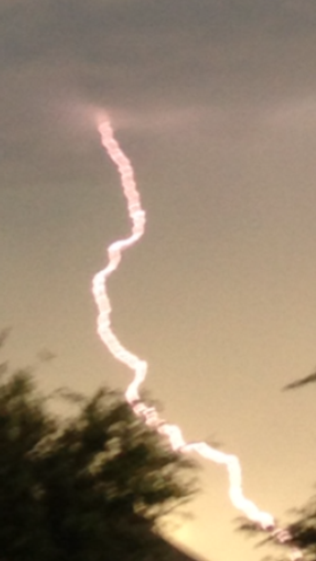
Near sunrise and sunset when the sky can turn colors of orange, pink and red, some of this light can illuminate the lightning bolt and make it appear a similar color to that of the background clouds. Check out the lightning photo I have on my facebook page that clearly shows what appears to be a “pink lightning bolt” only within a few miles of my iPhone camera when I snapped that picture. I have rarely seen lightning appear as vividly pink as in that photo, but it was clearly caused by the color hues from clouds at sunset contaminating the white lightning bolt.

So yes the ground observer can see lightning that “appears” to be many different colors…but the lightning bolt itself is always pretty close to white. The atmosphere, hail, distance, clouds and sunrise/sunset can at times give the bolt the appearance of many different color shades to the ground observer. Some of these color variations can tell you about how close or far the lightning might be; very yellow lightning normally is so far away that the audio thunder from it dissipates before it ever gets to you…so deep yellow lightning is often seen by your eyes, but is silent to the ear. 🙂